

You've finally found 'the one' in a leafy street, but then you open the brisbane flood map and see a splash of blue right across the lounge room. It's a heart-sinking moment, isn't it? You start wondering if you're about to buy a 'lemon' that no one will insure, or if the bank will simply knock back your loan application. It's completely normal to feel a bit rattled by technical terms like AEP and Overland Flow. Most people find the whole process of checking for flood risk confusing and, frankly, a bit stressful.
I'm here to tell you that a bit of blue on a map doesn't have to mean the end of your property dreams. I'll help you navigate these maps like a pro so you can understand exactly what you're looking at. We'll explore how to tell a 'nuisance' puddle from a real disaster risk, and I'll share how to secure a mortgage even when the big banks are being cautious. We will look at the latest 2026 insurance trends and how the new disclosure laws actually work in your favour. By the end, you'll have the confidence to bid on that Brisbane home without the 'what-if' keeping you up at night.
Key Takeaways
- Learn how to navigate the brisbane flood map and the FloodWise Property Report to identify specific risks before you even step foot inside an open home.
- Understand the crucial differences between river, creek, and overland flow so you can distinguish between a minor puddle and a major disaster risk.
- Discover how a property's flood rating can change your borrowing power and why some lenders are more "flood-friendly" than the big four banks.
- Get a clear picture of how insurance premiums are calculated in 2026 and how to estimate your ongoing costs before you sign a contract.
- Follow a simple step-by-step due diligence process to ensure you're buying a safe, insurable home rather than a "lemon."
How to Read the Brisbane Flood Map: Tools for Every Home Buyer
Have you ever looked at the brisbane flood map and felt like you were trying to solve a puzzle without the box lid? It is a lot to take in. You see different shades of blue and suddenly your dream home feels like a bit of a gamble. But don't worry. I have spent years looking at these maps for my clients; once you know what the colours mean, they become your best friend in the buying process. They aren't there to scare you off; they are there to help you make a smart, safe choice.
Brisbane has a long history with water. Looking back at the 2010-2011 Queensland floods helped the council improve their data, but the 2022 floods changed the game again. Because of this, the Brisbane City Council is constantly updating their models. In fact, the open data for the Brisbane River flood planning area was updated as recently as July 6, 2026. This is why you cannot just rely on what a neighbour tells you about "how high it got back in the day." You need the latest modelling to understand your actual risk today.
The Flood Awareness Map vs. FloodWise Property Report
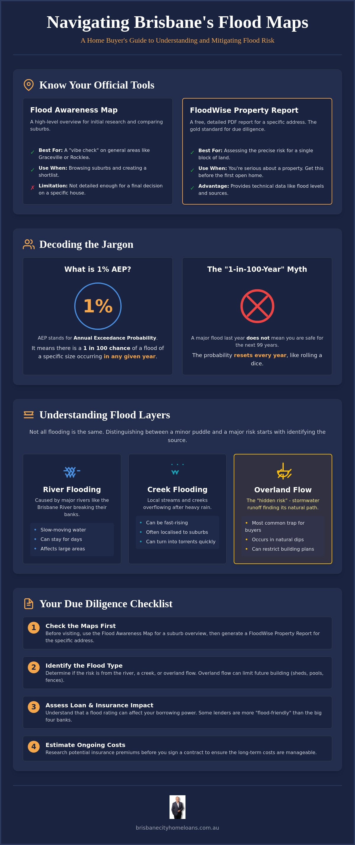
Think of the Flood Awareness Map as your "vibes check." It is a great starting point when you are browsing suburbs like Graceville or Rocklea. It gives you a broad look at which streets might get soggy. However, it is not detailed enough for a final decision. When you find a house you really love, you need the FloodWise Property Report. This is a free, technical PDF you can generate in seconds using the property's address. It is the gold standard because it looks at that specific block of land, not just the general neighbourhood. I always tell my clients to grab this report before they even go to the first open home.
Key Terms You Need to Know (Without the Jargon)
You will see the term "Annual Exceedance Probability" or AEP all over these reports. It sounds like something from a university textbook, but it is actually quite simple. AEP is just a number that tells us the chance of a flood happening at your house this year. If a report says a property has a 1% AEP, it means there is a 1 in 100 chance of that flood occurring in any given year.
This leads to the biggest myth in Brisbane real estate: the "1-in-100-year" flood. Many people think if a big flood happened last year, they are safe for the next 99 years. That is not how it works. It is like rolling a dice; just because you rolled a six once doesn't mean you won't roll it again on your next turn. We also need to look at "Future Planning Levels." These are the heights the council uses to decide how high new homes must be built to stay dry in the future. It is about looking forward, not just looking back at history.
Deciphering Map Layers: River, Creek, and Overland Flow
When you open the brisbane flood map, you aren't just looking at one simple type of risk. It is more like a multi-layered cake of water potential. Most people focus on the big river, but in Brisbane, water can come from the sky, the local creeks, or even the ocean. Understanding which layer is affecting your property is the first step to knowing if you can actually live there comfortably. Each layer tells a different story about how water moves through your potential backyard.
River flooding is the most famous type. Think of suburbs like St Lucia or Milton. When the Brisbane River breaks its banks, the water is usually slow-moving but can stay around for days. The 2022 floods showed us just how wide this reach can be, affecting roughly 23,400 properties across the city. Then you have creek flooding. Suburbs like Ashgrove or Coorparoo have beautiful green corridors, but those small streams can turn into fast-rising torrents in minutes. The council regularly updates these models to keep us safe. For example, Amendment Package V updated the creek mapping for Breakfast Creek and Lota Creek as recently as September 2025.
Why Overland Flow is the Most Common Trap
This is the 'hidden' risk that catches many buyers out on a sunny day. Overland flow is basically stormwater runoff trying to find its way to a drain or creek. If a property is in a natural dip, it becomes a temporary "mini-river" during a heavy downpour. You will see these as thin blue lines or hatched areas on the map. While it might not sound as scary as a river flood, it can seriously impact your plans. You often cannot build a pool, a shed, or even a solid fence if it blocks that water's path. Checking the official flood insurance information will help you see how these specific layers might impact your yearly costs.
Suburbs with Unique Flood Profiles
Don't let a suburb's reputation scare you off entirely. Places like Rocklea, Oxley, or Fairfield have a well-known history with water, but they also contain plenty of high-and-dry streets that have never seen a puddle. Conversely, newer developments in areas like North Lakes or Springfield are designed with modern drainage systems, though they still have their own mapping quirks to keep an eye on. It is all about the specific block, not just the postcode. If you are feeling a bit overwhelmed by the blue lines on your screen, I can help you compare your loan options across 60+ lenders to see which ones are the most comfortable with the specific risk profile of your chosen home.
For those looking toward the coast in Wynnum or Lota, the storm tide layer is your main focus. This shows where the ocean might be pushed inland during a severe weather event. It is a very different beast to a river flood, but just as important for your long-term peace of mind. No matter where you are looking, knowing exactly which layer you are dealing with makes the whole process feel much more manageable.
How Flood Maps Impact Your Brisbane Home Loan and Insurance
It is one thing to look at a map and think, 'I can handle a bit of water,' but it is another thing entirely to hear the bank say, 'We won't give you the money.' Banks and insurers are joined at the hip when it comes to the brisbane flood map. If the map shows a property is at high risk, the bank sees a potential loss. This often means they will only lend you 80% of the property's value, even if you were planning on a smaller deposit. In 2026, lenders are using sophisticated tools to check every address before they even look at your payslips.
Your borrowing capacity takes a direct hit from these maps too. When a bank calculates how much you can afford, they include your living expenses and insurance costs. In a low-risk area, you might pay between $800 and $1,500 a year for cover. But in a high-risk flood zone, those premiums can skyrocket to $15,000 or more. That is over $1,200 a month just for insurance. The bank sees that as a huge chunk of money that isn't available for mortgage repayments, which can shrink your loan amount by tens of thousands of dollars. Even Lenders Mortgage Insurance (LMI) providers have become incredibly picky; they often use the Brisbane City Council Flood Awareness Map to decide if they will even offer you a policy.
What Happens During a Bank Valuation?
A valuer doesn't just look at your nice kitchen. They check the "Habitable Floor Levels" against the council's flood data. If the main living areas are below the expected flood height, they will likely "flag" the property. This can lead to a lower valuation, leaving you with a "valuation gap" you have to cover in cash. If you are already an owner and seeing your costs climb, you might want to Refinance Your Investment Property Loan in Brisbane to find a better deal with a lender who is more comfortable with your postcode.
The Uninsurable Property: A Deal-Breaker?
Banks usually won't let you settle on a home unless you can prove it is insured. If the brisbane flood map shows a property is in a severe risk zone, some insurers might refuse to cover it entirely. This is a massive red flag. If you can't get insurance, you usually can't get a loan. This is where I come in. I spend my days talking to over 60 different lenders to find the ones who have a more realistic view of Brisbane's geography. We "pre-flight" your application by checking which banks are happy to lend in your specific street, so you don't get a nasty surprise a week before settlement.
Due Diligence Steps for Properties in Flood-Prone Areas
So, you've spotted a house you love, but the brisbane flood map shows a bit of blue nearby. Don't walk away just yet. It's time to put on your detective hat and do some digging. Buying in a flood-prone area doesn't have to be a disaster if you know exactly what you're getting into. Think of it as a checklist to protect your future self from nasty surprises. You want to be the buyer who knows more than the agent, not the one who finds out the hard way after settlement.
- Step 1: Get the FloodWise Report. Do this before you even go to the open house. It's free and tells you the exact flood levels for that specific block.
- Step 2: Look for physical clues. When you're at the property, look at the fences. Are there water marks? Is the house "high-set"? Check if the downstairs area has been built in with flood-resilient materials like concrete or tiles rather than carpet and plasterboard.
- Step 3: Get a "hypothetical" insurance quote. Call an insurer and give them the address. In 2026, we're seeing premiums in high-risk areas range from $5,000 to over $15,000. You need to know if you can afford the "running costs" of the house.
- Step 4: Chat with the neighbours. Brisbane locals are a friendly bunch. Ask them where the water went in 2022. Nothing beats "boots on the ground" knowledge from someone who was actually there.
- Step 5: Talk to your broker. I can check if your chosen lender has a "blacklist" for that street or if they've recently changed their policy for that suburb.
Building and Pest Inspections with a Flood Lens
When you book your inspector, tell them the property is in a mapped zone. Ask them to check specifically for sub-floor moisture or structural issues from past events. Take a look at the electrical outlets and the aircon compressor too. Are they raised off the ground? A "Flood Resilience Audit" is a great idea for older Queenslanders; it tells you how to make the home easier to clean out if the worst happens. If you're feeling unsure about the money side of things, you can book a quick chat with me to see how these factors affect your borrowing power.
The "Subject to Finance" Safety Net
This is the most important advice I can give you: never waive your finance clause when buying in a mapped zone. You need that time to make sure the bank's valuer is happy and the insurance isn't going to cost a fortune. You can even ask your solicitor to add a specific "subject to satisfactory insurance" clause. If you're a beginner, our First Home Buyers QLD guide covers all the basics of navigating your first contract without the stress.
Navigating Flood Risks with a Brisbane Mortgage Broker
Looking at the brisbane flood map can feel a bit like reading a weather report for a storm that hasn't happened yet. It's easy to get overwhelmed by all those blue shaded areas. That's exactly where I come in. Think of me as your local guide who knows the terrain just as well as the bank's spreadsheets. While a computer algorithm at a big bank might see a postcode and automatically hit 'decline', I know that Brisbane is a city of unique hills and gullies. One street might be a 'Rocklea risk' while another is a 'Rosalie risk', and they both need a different approach when it comes to finance.
I have access to over 60 different lenders, and this is a total game-changer for properties with a bit of a history. Many of these lenders are much more flexible than the big four banks. We 'pre-flight' your application by checking specific lender policies against the map data before we even hit 'submit'. This saves you from unnecessary marks on your credit file and gives you a much clearer path to approval. We take the stress out of the 'blue bits' so you can focus on the exciting part: choosing your new home.
Andrew’s Personal Approach to Brisbane Property
I've helped heaps of locals who were worried they'd never get a loan because of a bit of overland flow in their backyard. I remember one couple who were told 'no' by their own bank of ten years. We looked at the actual floor height of the property, found a lender who understood the 2022 data better, and got them settled in time for Christmas. I reckon it's important to have a 'let’s find a way' attitude. You won't find any judgment here; just clear, honest advice on how to make the money side of things work for the home you want.
Your Next Steps: From Map to Mortgage
Ready to move from staring at maps to actually holding the keys? The best way to start is with a free, low-pressure chat. You can book a time with me here and we can go through your target suburbs together. It's helpful if you can bring along a FloodWise report for any specific houses you've got your eye on, but if not, we can pull them up during our meeting. We'll look at your deposit, your goals, and which lenders are currently the most 'flood-friendly' for your situation. Just remember that a bit of flood risk is simply another factor to manage in our beautiful river city, not a reason to give up on your Brisbane property dream.
Ready to Buy with Confidence in Brisbane?
Buying a home should be an exciting milestone, not a source of constant worry. While the brisbane flood map might look a bit intimidating at first, it is really just a tool to help you make a smarter decision. Remember, a splash of blue on a report doesn't mean you have to give up on a property you love. It just means you need to check your insurance quotes early and ensure your lender is comfortable with the specific risk profile of that street.
I have spent years helping locals navigate these exact challenges. With access to 60+ Australian lenders and 100% local Brisbane expertise, I can help you find a path forward that the big banks might miss. My service is completely free for all borrowers, so you have got nothing to lose by getting a bit of expert advice. We can look at the data together and find a solution that fits your budget and your future.
Ready to take the next step? Book a free, no-obligation chat with Andrew to talk about your Brisbane property goals. We will look at your target suburbs and make sure you are set up for success. You have got this, and I am here to help you every step of the way.
Frequently Asked Questions
How often does Brisbane City Council update the flood maps?
The council updates these maps whenever new data or better modelling becomes available. For example, the open data for the Brisbane River flood planning area was updated as recently as July 6, 2026. This ensures that the brisbane flood map reflects the most current understanding of our river city. It is always a good idea to check the live version before you attend an auction, as risk profiles can change as the science improves.
Can I get a home loan for a property that flooded in 2022?
Yes, you certainly can, though the process usually involves a few extra steps. Lenders will typically want to see that any damage has been professionally repaired and that you can secure a valid insurance policy before settlement. Some banks might be more conservative with their valuations or limit your borrowing to 80% of the property's value. I can help you find the specific lenders who are more comfortable with these types of properties.
What is the difference between river flooding and overland flow on the map?
River flooding happens when the Brisbane River breaks its banks, which usually affects large areas and can stay around for several days. Overland flow is different; it is basically stormwater runoff trying to find its way to a drain during a heavy downpour. You will see both on the brisbane flood map, but overland flow is often more localised and can impact where you are allowed to build things like sheds, decks, or pools.
Does a "blue" rating on the map always mean my insurance will be expensive?
Not necessarily, as it depends on the depth and frequency of the risk. Insurers look at the specific data for your block to decide if the risk is a 'nuisance' or a 'disaster'. While some high-risk areas can see premiums over $15,000, properties with only minor overland flow might still have very affordable cover. It is always best to call an insurer for a hypothetical quote using the specific address before you sign a contract.
What is a 1-in-100-year flood level, and is it still accurate in 2026?
This term is actually a bit of a myth; it really means there is a 1% chance of that flood level occurring in any given year. In 2026, we use more sophisticated modelling that includes data from the 2022 event to stay as accurate as possible. Just because a big flood happened recently doesn't mean you are safe for the next 99 years. It is like rolling a dice; the odds stay the same every time.
Can a mortgage broker help if my bank rejected my loan due to flood risk?
Absolutely, because every lender has a different 'appetite' for risk. Just because one big bank said no doesn't mean they all will. I have access to over 60 different lenders and can 'pre-flight' your application to find the ones that are happy with your specific street. We look for lenders who use realistic data and understand the local Brisbane market better than a computer algorithm in another state might.
Is it better to buy a high-set house in a flood zone?
Generally, yes, because keeping your main living areas above the predicted water level is a huge plus for both safety and finance. Banks and insurers focus on 'habitable floor levels' when they decide on your loan and your yearly premiums. A high-set Queenslander can often be much easier to insure and may even help you avoid a lower bank valuation compared to a low-set brick home on the very same street.
Where can I find the historic flood levels for a specific Brisbane street?
The most reliable place to look is the Brisbane City Council’s FloodWise Property Report. This free technical document gives you a detailed breakdown of how high the water has reached on that specific block in the past. It is much more accurate than local rumours and is the exact same data that banks and insurers use to make their decisions. I always recommend grabbing this report before you even step inside an open home.


